

Chaotic weather can have unpredictable consequences, but some areas of Kitsap County may have a better bead on its effects going forward.
The National Weather Service, the federal meteorological group that tracks weather and safety advisories regarding inclement events, has reorganized its public forecast zones throughout Western Washington, the agency announced March 19.
Meteorologists have established 13 new forecast zones and adjusted the boundaries of all but one of the 21 existing zones, creating 34 forecast areas from the Pacific Ocean to the Canadian border, south to Olequa, WA and east to Snoqualmie Pass.
The new zones reflect elevation, climatology, major transportation routes and population centers. The change will provide more specific weather warnings to communities susceptible to dangerous impacts without having to alarm residents who may live nearby, but are out of harm’s way.
“Each county within the [area] features complex terrain and a wide array of localized weather effects. The previous configuration could result in considerable over- or under-warning of communities due to their size and climatological diversity contained within each zone,” officials wrote.
“For instance, an entire zone may be alerted when only a small portion of the zone is expected to experience the weather hazard, or a decision is made not to issue an alert altogether for the same reason. These limitations can cause confusion when trying to relay hazardous weather messages to our partners and the public.”
But where most of the previous zones became more complex, Kitsap’s got simpler.
County residents once had three forecast zones to keep track of — one for the cities on Puget Sound, one for the towns on Hood Canal, and one that put Kingston and Point No Point in the same zone as Warm Beach in Snohomish County. Now, there are two zones on the east and west sides of Highway 3 that stretch through the entire county, with the split following Highway 104 in North Kitsap and ending at Rose Point.
Kitsap’s western forecast zone, which once spanned the entire Hood Canal and reached all the way to the end of Tolten Inlet, was also separated into three sections: North Hood Canal, South Hood Canal, and Olympia and Southern Puget Sound.
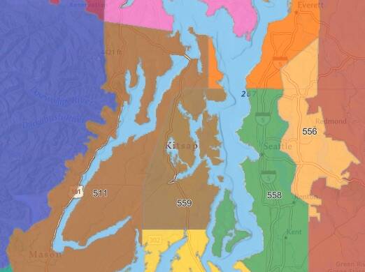
A zoomed-in map of the previous forecast zones for Kitsap County.